
INCIDENT COMMAND SOFTWARE

Adashi C&C
Incident command software for UK Fire Service.
Incident management like never before.
The C&C incident command software serves as a robust situational awareness and asset management platform for fire brigades and commanders. C&C gives commanders an interactive dashboard for effective decision making in the command center and on the incident ground. Designed for all types and sizes of incidents, C&C helps commanders across the UK improve the communication and coordination of emergency services.

For UK Emergency Services
The Adashi C&C solution is designed specifically to meet the needs of the UK Fire & Rescue Service. The multiple map interfaces help fire brigades mobilise assets and respond to incidents quickly . Our incident management solution provides situational awareness, real time collaboration, tactical planning, tracking, management, communication, logging, and reporting.
C&C is also an approved supplier in the YPO Framework. UK public sector organisations can purchase Adashi’s C&C directly through YPO and do not need to run a full procurement through the Official Journal of the European Union (OJEU). For more information, check out our recent press release.
C&C integrates with Adashi’s other products to provide an end-to-end solution for our customers. From scheduling the right people before the incident to efficiently logging the incident when response is finished, we have the tools to help public safety agencies of all types manage incidents safely and effectively.
Learn more about C&C’s Features
Real Time Collaboration
Use annotation to share a single encompassing view of the incident with other connected users. Commanders can quickly determine and communicate points of interest such as hazards, cordon zones, and staging areas.
Map-based Management
Built-in gazetteer instantly recognizes addresses and provides multiple map views. Choose from your ESRI layers, Google, Bing, Pictometry (where available) and Navteq maps for real-time situational awareness.
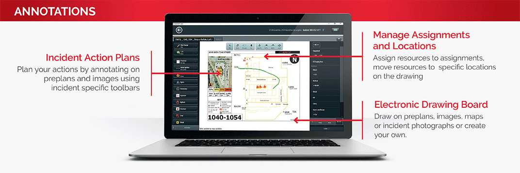
Incident Action Plan
Use the electronic tactical worksheet to develop a detailed Incident Action Plan, and assign resources directly onto the map. Drag and drop to efficiently manage roles, and define your strategy and game plan with all connected resources.
CAD and RMS integration
Transfers data automatically or on demand, eliminating redundant data entry and ensuring accuracy. Critical information including address/coordinates, incident notes, contact information, and responding units is available to the incident commander.
Incident Command
Like Never Before.
Incident Management System Features
Learn more about Adashi C&C.
Collaboration & Common Operating Picture
Map-Based Management – With multiple map views at your fingertips, manage your incident directly on a map. Choose from your ESRI layers, Google, Bing, Pictometry (where available) and Navteq maps. Draw on the map, view and place resources on a map, and share maps for real-time situational awareness and a common operating picture.
Resource Management and Tracking – Full AVL (Automatic Vehicle Location) allows incident commanders to see, communicate, and re-route units in real time. Resources in the field instantly receive a pop-up notification of messages and the new assignment. Easily drag and drop roles and resources on the map to reflect either their current or planned location and include messages with their new assignments.
Incident Action Plan – Use the electronic tactical worksheet to develop a detailed Incident Action Plan, and assign resources directly onto the map. Drag and drop to efficiently manage roles and resources within the incident display. Define your strategy and game plan with all connected resources.
Collaboration – Get everyone on the same page fast. Use annotation to share a single encompassing view of the incident in real time with other connected users. Personnel can share information, photographs and collaborate in the collection of accurate and timely data.
Electronic Drawing board – Draw and drag icons on the map to mark boundaries, define zones of approach, identify objectives, notate hazards or define cordon zones, staging areas, and more. Draw on maps, photographs, pre-plans and other media. Share your strategy with all connected resources.
Intelligence & Coordination
Organizational Hierarchy Chart – When an incident is initiated, a flexible incident command org chart allows you to drag and drop your resources to groups and assignments. Organizational charts expand as the incident progresses. Maintain critical span of control at each level with ease.
Pre-plans – Access and view pre-plan data and documents such as building plans, response plans, hydrants, hazards, and photographs. These pre-defined items of interest will appear automatically when the associated address or selected perimeter is chosen by you or your CAD. Annotate the pre-plan with crew entry points, icons, tasks, and responsibilities. Use this capability to draw boundaries, define zones of approach, identify objectives, notate hazards or define cordon zones, staging areas, and more.
Easy CAD Integration – Upon CAD dispatch, data is automatically transferred. Critical Information, including Address/Coordinates, Incident Notes, Contact Information and responding units is available to the incident commander.
All-Hazards Database Management – Add and modify hazard categories, types and descriptions as needed to fit your organisation’s specific needs. Add guidance, SOGs, local response plans, and other critical data to specific incident types. Use the pre-loaded repository of CAMEO/ALOHA hazard data, identification, and reference tools. Populate your maps with automated airborne hazard prediction and map visualization of hot/warm zones, isolation distances, and evacuation areas based on real-time weather.
Benchmarks and Checklists – Customisable benchmarks and checklists are available at the touch of a button. All activities are time stamped and recorded in the log.